Loading
Just a moment…
Loading
Just a moment…
Geography is the study of places on Earth: where they are, what they are like, and how they connect. You will use two tools all year: a globe and a flat map. A globe keeps Earth's true round shape, but it is bulky and half of it always faces away from you. A flat map folds and fits in a book, but it always gets something wrong. By the end of this lesson you will know what each tool keeps, what each one gives up, and why the very first thing to read on any map is its title.
Earth is very nearly a sphere — not perfectly round, since spinning makes it bulge slightly at the equator, but close enough that a smooth ball is an honest model. A globe keeps four things at once: shapes are right (Italy has its real outline), sizes are right compared with each other (Africa really is many times larger than Greenland), distances are right, and directions are right. No flat map of the whole world can promise all four at the same time.
Say these three lines until you know them by heart:
"A globe keeps shape, size, distance, and direction all at once."
"A map is flat, so every map must stretch or leave something out."
"Ask what a map was made to show before you trust it."
A globe is a model, and a model always leaves things out on purpose. A model aeroplane has no engine. A dollhouse has no plumbing. A school globe has no streets, no weather, and a mountain range squeezed into a smear of brown. It also has a problem you can feel: half of it always faces away from you. To see the Pacific and the Atlantic at once, you have to turn the ball and hold both halves in memory. The flat map exists because that is inconvenient — not because anyone thought a flat Earth was a good idea. A subway diagram is another honest selection: it keeps the order of the stops and the places to change lines, and gives up true street distance and true shape to do that job well.
Try this: wrap a strip of paper smoothly around an orange's middle, then up over the top. It wrinkles or tears — it cannot lie flat with no gaps. Now peel the orange in one piece and press the peel flat on the table. The peel splits or stretches. That is not clumsiness. A curved surface and a flat surface are different shapes, and moving from one to the other always costs something. The rule a mapmaker uses to move points from the curved Earth onto a flat page is called a projection.
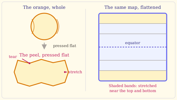
There are hundreds of projections, and every one of them chooses. A projection built for sailors keeps compass directions straight, which is exactly what a ship needs — and pays for it by stretching the far north and far south until Greenland swells to the size of a continent. A projection built for comparing countries keeps areas honest and pays for it by bending shapes. Some maps even cut the ocean into wedges so the land can lie flat. The right question about a world map is never "is this right?" It is: what was this map made to do, and what did it give up to do it?
Greenland is the largest island in the world, lying far to the north between the Atlantic and the Arctic. Its area is about 2.2 million square kilometres, or roughly 840,000 square miles. An ice sheet covers about four-fifths of it, in places more than two kilometres thick. Almost everyone lives on the ice-free coastal strip, chiefly in the southwest, where the capital, Nuuk, stands. The whole population is only about 56,000 people — fewer than live in many ordinary towns. Greenland governs most of its own affairs and belongs to the Kingdom of Denmark. Notice how much this one place can teach: its true size, hidden by one kind of map, is exactly the test you will use on every world map from now on.
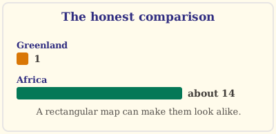
On a common rectangular world map, Greenland often looks about as big as Africa. Put a globe beside that map and the claim collapses: Africa is about fourteen times larger. Greenland has not changed size — the map stretched it, because that kind of map stretches places more and more the farther they lie from the equator, and Greenland lies very far north indeed. Make this your standing test: whenever a new world map appears, find Greenland, find Africa, and ask which looks bigger. The answer tells you a great deal about the map before you read a single word of its title.
Cut a small paper square, about the size of a stamp. On a flat world map, count how many squares it takes to cover Greenland, then how many to cover Africa. Write both numbers down. Now do the same on a globe, using a scrap of paper that bends to the curve. The two counts will not agree — the flat map has enlarged one of them. The globe gives the honest comparison, and it says Africa is many times the larger of the two.
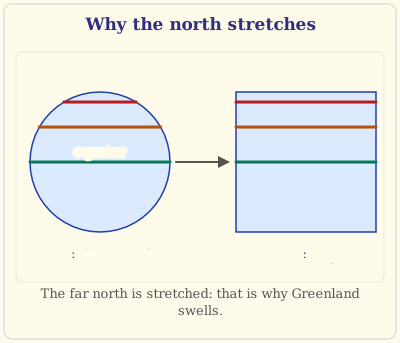
Wrap a paper strip around a ball at its middle (the equator). It lies flat and neat. Now slide the same strip toward the top of the ball and try again. It will not sit — the strip is too long for the smaller circle up there, so it wrinkles. The only cures are to cut it or to stretch the ball. A mapmaker who insists on drawing a rectangle has chosen to stretch instead of cut. That single wrinkle near the pole is why Greenland swells on a rectangular map.
A family wants to know which route to drive to a cousin's house. A road map answers that; a map of yearly rainfall does not. The rainfall map is not a bad map — it is answering a different question, and it says so in its title. A subway diagram often straightens the tracks and spaces the stops evenly. It is excellent for reading the order of stops and where to change lines, and poor for measuring how far you would actually walk on the streets above. Its usefulness comes from choosing what to show, not from showing every true distance.
You might be tempted to think a map is either simply right or simply wrong. Don't — ask instead which of the four things (shape, size, distance, direction) this particular map keeps, and whether those are the ones its job needs.
You might be tempted to think the country that looks biggest on the page is really the biggest. Don't — go straight to Greenland and Africa on a globe. Looking big on one sheet of paper is a fact about the sheet, not about the world.
You might be tempted to think a globe shows everything exactly as it is. Don't — a globe is a model too. It has no streets and no changing borders; it simply flattens nothing.
You might be tempted to think the mapmaker who stretched the north made a mistake. Don't — a sailor's straight compass course has to be a straight line on the page, and the stretching is the price of that. It is a trade, made on purpose.
You might be tempted to think a photograph from space is a map. Don't — a photograph records whatever the camera saw, with nothing chosen. A map chooses what to show, names it, and leaves other things out. Choosing is exactly what makes it a map rather than a picture.
| Term | What it means |
|---|---|
| geography | The study of places on Earth: where they are, what they are like, and how they connect. |
| globe | A round model of Earth, which keeps shape, size, distance, and direction all at once. |
| map | A flat drawing of a place that shows some things on purpose and leaves other things out. |
| projection | A rule for putting the curved surface of Earth onto a flat page. |
| distortion | The stretching, squeezing, or bending a flat map does to shape, size, distance, or direction. |
You have finished the most important habit of the whole year: looking at a map and asking what it was made to do, before believing everything it seems to show. Next time, the map stops being the subject and starts being a place to work. You will learn the eight compass directions, why "north" and "up" are not the same word, and meet a real city whose ancient names for north and south run the opposite way from the top and bottom of the page.